סמינר מחלקתי - Spatio-temporal dynamics of the urban fringe landscapes
יוליה גרינבלט (PhD)
Spatio-temporal dynamics of the urban fringe landscapes
מנחים: פרופ' יצחק בננסון, פרופ' דניאל צ'מנסקי
Yulia Grinblat
The Porter School of Environmental Studies, Tel Aviv University
Department of Geography and Human Environment, Tel Aviv University
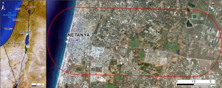
Land Use/Cover Change (LULC) is a complex process caused by the interaction of various actors and factors at different spatial and temporal levels. Typically, the core of land uses is relatively stable and homogeneous, whereas their fringes are heterogeneous, with complex interfaces appearing between themthat change relatively fast. These constantly growing and unstable areas are a source of environmental, social, and economic concerns associated with LULC.
In addition, global urban patterns can be described as having a cumulative and an aggregated order that results from numerous local and global projects made decisions involving a large number of actors on various scales(Cheng and Masser 2004; Broitman and Czamanski 2015). Large-scale projects are characterized by heavy investments and long-term construction, while small-scale projects may be described as rapid construction and light investments. These two types of growth have qualitatively different causes and have different consequences.A complex landscape mosaic is comprised of several dynamic systems, each with its own transition possibilities and characteristic temporal changes. Thus, the main objective of the study is to develop a spatially explicit urban project-based model along these fringe landscapes that will clearly distinguish between changes occurring along and beyond fringe.
Conceptual simplicity and the ability of explicit representation of landscapes and their changes make Cellular Automata (CA) a standard tool for simulating urban and regional land-use dynamics (Clarke et al. 1996; White and Engelen 1997), which potential for modeling LULC dynamics is widely recognized (Wu and Webster 1998; Pijanowskiet al. 2002; Verburget al. 2002). Typically, the CA models focus on estimating the rules of the LULC changes and analysis of thesimulation results. However, the models put aside the uncertainty of the LULC maps that are used for establishing the transition rules. One of the main questions of the study is the reliability of Remote Sensing (RS) data sources and classificationmethods applied for constructing these LULC maps.
Strangely enough, the adequacy of the RS classification for representing LULC changes remains on the margin of the CA modeling studies. Despite a series of publications that regard the erroneous consequences of misclassification (van de Voordeet al. 2009; van der Kwastet al. 2009) and sensitivity of the CA dynamics to the parameters of the CA rules (Liu and Andersson 2004; Jantz and Goetz 2005; Dietzel and Clarke 2006), the majority of modeling studies carelessly exploit the simplest methods of the RS images classification, take their outputs for granted, and focus on model calibration. This may evidently result in inadequate transition rules regardless of the calibration methods. LANDSAT imagery is a common choice of RS data, due to its wide range of temporal and spatial coverage. I thus also investigate the adequacy of different methods of LANDSAT images classification for establishing CA model rules of LULC dynamics.